
Geography | Indian Rivers | General Knowledge | Competitive Exams
Ganges river in Himalayas mountains
Assam Tee – Herkunft und Wiege des indischen Teeanbaus – Nibelungentee
8
Introduction
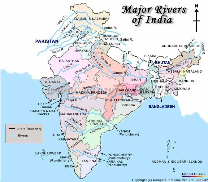
India is a land of diverse geographical features, including mountains, plateaus, plains, valleys and coastal regions. The rivers of India play a vital role in shaping the country’s geography, economy, agriculture and civilization.
Indian rivers provide water for irrigation, drinking, industries, hydroelectric power generation and transportation. They also support biodiversity and create fertile agricultural plains.
The rivers of India are broadly classified into two major groups:
- Himalayan Rivers
- Peninsular Rivers
Apart from these, some rivers form an inland drainage system and do not reach the sea.
In this article, we will explore the major river systems of India, their origin, tributaries, drainage patterns, important dams and geographical significance.
1. Classification of Indian Rivers
Indian rivers are classified mainly on the basis of their geographical origin and characteristics.
| Feature | Himalayan Rivers | Peninsular Rivers |
|---|---|---|
| Origin | Himalayas and adjoining highlands | Peninsular Plateau and Western Ghats |
| Nature | Mostly perennial | Mostly seasonal, with some important exceptions |
| Main source of water | Glaciers, snowmelt and rainfall | Mainly monsoon rainfall |
| River valleys | Deep valleys and gorges in upper courses | Broad valleys and rocky courses |
| Drainage pattern | Often dendritic and antecedent | Commonly dendritic and structurally influenced |
| Major rivers | Indus, Ganga, Brahmaputra | Godavari, Krishna, Kaveri, Narmada, Tapi |
Important Geography Fact: Himalayan rivers are generally perennial because they receive water from both rainfall and melting snow. Peninsular rivers depend more heavily on seasonal rainfall.
2. Himalayan River Systems
The Himalayan river system consists of three major river systems:
- The Indus River System
- The Ganga River System
- The Brahmaputra River System
These rivers originate in or near the Himalayan region and drain large areas of northern India.
National Mission for Clean Ganga
Map of Brahmaputra Basin. Source: Indian Institute of Technology,… | Download Scientific Diagram
A. The Indus River System
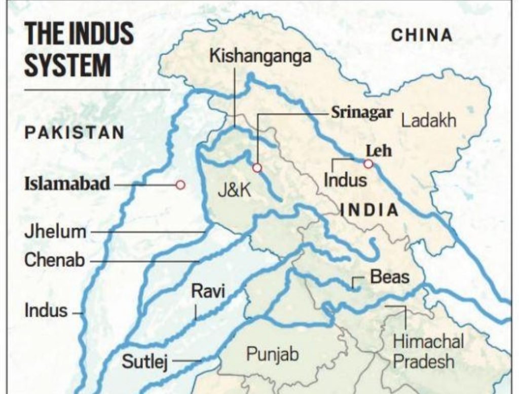
The Indus is one of the most important rivers of the Indian subcontinent.
Important Facts About the Indus River
- Total length: Approximately 3,180 km.
- Length in India: Approximately 709 km, according to the supplied textbook.
- Origin: Near Bokhar Chu glacier in the Kailash Range of Tibet, close to Lake Mansarovar.
- It is known as Singi Khabban in Tibet.
- It flows through Tibet, India and Pakistan.
- It ultimately drains into the Arabian Sea.
Major Tributaries of the Indus
| Tributary | Approximate Length |
|---|---|
| Jhelum | 725 km |
| Chenab | 1,800 km |
| Ravi | 720 km |
| Beas | 470 km |
| Sutlej | 1,050 km |
These rivers are commonly associated with the Punjab region, whose name is historically linked with the five rivers.
Origin of Important Tributaries
| River | Source |
|---|---|
| Jhelum | Verinag, Kashmir |
| Chenab | Bara Lacha Pass, Himachal Pradesh |
| Ravi | Near Rohtang Pass, Himachal Pradesh |
| Beas | Near Rohtang Pass, Himachal Pradesh |
| Sutlej | Near Lake Mansarovar, Tibet |
Indus Water Treaty
- The Indus Water Treaty was signed between India and Pakistan in 1960.
- It regulates the use of the waters of the Indus river system.
- The eastern rivers are Ravi, Beas and Sutlej.
- The western rivers are Indus, Jhelum and Chenab.
- Under the treaty’s original allocation framework, India has unrestricted use of the eastern rivers, while the western rivers are primarily allocated to Pakistan, subject to specified uses permitted to India.
Important Projects on the Indus River System
- Kishanganga Project
- Tulbul Project
- Baglihar Project
These projects are associated with hydropower generation and water management.
B. The Ganga River System
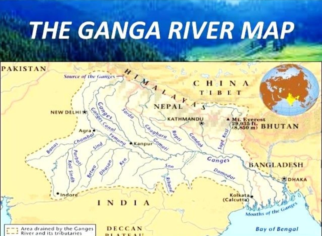
The Ganga is one of the most important rivers in India. It is known for its religious, cultural, agricultural and geographical significance.
mountain river flowing in a deep canyon
India, Uttar Pradesh, Varanasi,
8
Important Facts About the Ganga
- Total length: Approximately 2,525 km.
- It originates in the Himalayan region of Uttarakhand.
- The headstream of the Ganga is formed by the Bhagirathi and Alaknanda rivers.
- The Bhagirathi originates from the Gangotri Glacier near Gaumukh.
- The Alaknanda originates from the Satopanth Glacier region.
- The two rivers meet at Devprayag, where the combined river is called the Ganga.
- The Ganga flows through Uttarakhand, Uttar Pradesh, Bihar, Jharkhand and West Bengal.
- It ultimately drains into the Bay of Bengal through the Ganga-Brahmaputra delta.
The Five Important Prayags
The confluences of important Himalayan rivers in Uttarakhand are known as Prayags.
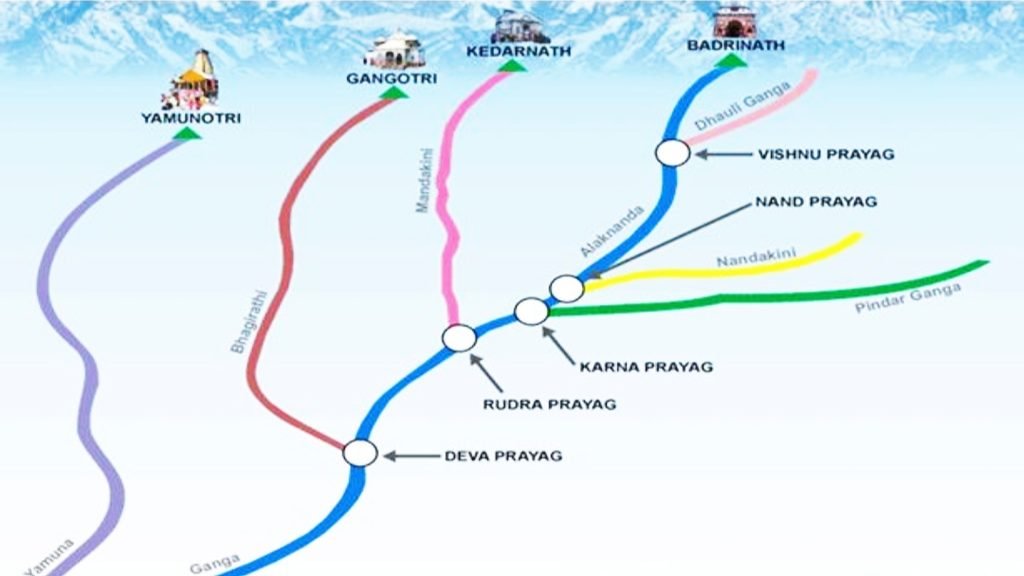
| Prayag | Rivers Meeting |
|---|---|
| Vishnuprayag | Alaknanda + Dhauliganga |
| Nandaprayag | Alaknanda + Nandakini |
| Karnaprayag | Alaknanda + Pindar |
| Rudraprayag | Alaknanda + Mandakini |
| Devprayag | Alaknanda + Bhagirathi |
Correct sequence of the five Prayags:
Vishnuprayag → Nandaprayag → Karnaprayag → Rudraprayag → Devprayag
Ganga River Flow Diagram
Gangotri Glacier
Origin of the Bhagirathi
Bhagirathi + Alaknanda
Meet at Devprayag
Ganga
Flows through the northern plains
Ganga-Brahmaputra Delta
Bay of Bengal
Major Tributaries of the Ganga
The Ganga has numerous tributaries that contribute to its enormous drainage basin.
| Tributary | Important Fact |
|---|---|
| Yamuna | Major right-bank tributary |
| Ghaghara | Important Himalayan tributary |
| Gandak | Major tributary from Nepal |
| Kosi | Known as the Sorrow of Bihar |
| Son | Important tributary from the south |
| Gomti | Important tributary of the Ganga |
| Damodar | Known as the Sorrow of Bengal |
Yamuna River
- Approximate length: 1,375 km.
- Origin: Yamunotri Glacier in Uttarakhand.
- It flows approximately parallel to the Ganga for a considerable distance.
- It joins the Ganga at Prayagraj (Allahabad).
- Major tributaries include Chambal, Sind, Betwa and Ken.
- The Chambal is an important tributary of the Yamuna.
The Ganga Delta
- The combined Ganga-Brahmaputra river system forms the world’s largest delta.
- The delta is known as the Sundarbans.
- It covers a vast region of India and Bangladesh.
- The delta is famous for mangrove forests and rich biodiversity.
Ganga in West Bengal
- The Bhagirathi-Hooghly is an important distributary system of the Ganga in West Bengal.
- The Hooghly flows through Kolkata and eventually reaches the Bay of Bengal.
- The Farakka Barrage is an important water-management structure on the Ganga in West Bengal.
- It helps divert water towards the Hooghly to support navigation and manage sediment deposition.
C. The Brahmaputra River System
The Brahmaputra is one of the major Himalayan river systems. It is known for its enormous water discharge, wide floodplains and extensive drainage basin.
The world’s biggest hydropower project breaks ground in Tibet
Navayuga Engineering Company Ltd.
8
Important Facts About the Brahmaputra
- Total length: Approximately 2,900 km.
- Length in India: Approximately 885 km.
- Origin: Chemayungdung Glacier region in Tibet.
- It is known as the Yarlung Tsangpo in Tibet.
- It enters India through Arunachal Pradesh, where it is known as the Dihang or Siang.
- It takes a major U-turn near Namcha Barwa.
- It flows through Assam and enters Bangladesh.
- In Bangladesh, the Brahmaputra is commonly known as the Jamuna.
- The Ganga is known as the Padma in Bangladesh.
- The Meghna is another major river system that joins the combined river system before it enters the Bay of Bengal.
Important Tributaries of the Brahmaputra
- Subansiri
- Kameng
- Dhansiri
- Manas
- Dibang
- Lohit
- Teesta
Brahmaputra River Flow Diagram
Chemayungdung Glacier
Tibet — Yarlung Tsangpo
Namcha Barwa
Major U-turn in the river course
Dihang / Siang
Arunachal Pradesh
Brahmaputra
Assam → Bangladesh (Jamuna)
Bay of Bengal
Through the Ganga-Brahmaputra-Meghna system
Majuli Island
- Majuli is a river island in Assam.
- It is located in the Brahmaputra River.
- It is famous for its cultural heritage and riverine landscape.
- Its size and shape are affected by river erosion and sediment deposition.
3. Peninsular Rivers of India
Peninsular rivers originate mainly from the Peninsular Plateau and the Western Ghats.
Important Characteristics
- Most Peninsular rivers depend heavily on monsoon rainfall.
- Their flow is generally more seasonal than that of Himalayan rivers.
- Many rivers flow from west to east.
- Most east-flowing rivers form deltas near their mouths.
- The Narmada and Tapi are major west-flowing rivers.
- Many Peninsular rivers follow the general slope of the plateau.
Peninsular rivers can be divided into two groups:
- East-flowing rivers
- West-flowing rivers
A. East-Flowing Rivers
These rivers generally drain into the Bay of Bengal.
Mahanadi River Delta by Planetobserver / Science Photo Library
Andhra Pradesh: India’s unknown backwaters destination | Rough Guides
Krishna River Gorge near Srisailam, Andhra Pradesh, India
9
Major East-Flowing Rivers
| River | Approximate Length | Origin | Important Fact |
|---|---|---|---|
| Mahanadi | 858 km | Chhattisgarh | Forms a delta in Odisha |
| Godavari | 1,465 km | Nashik, Maharashtra | Longest Peninsular river |
| Krishna | 1,327 km | Near Mahabaleshwar | Major east-flowing river |
| Kaveri | 805 km | Brahmagiri Hills | Important river of southern India |
| Pennar | 597 km | Nandi Hills region | Flows through Karnataka and Andhra Pradesh |
1. Mahanadi River
- Approximate length: 858 km.
- Origin: Dhamtari district, Chhattisgarh.
- It flows through Chhattisgarh and Odisha.
- It drains into the Bay of Bengal.
- Important tributaries include Ib, Seonath, Hasdeo, Mand and Jonk.
- The Hirakud Dam is an important multipurpose project on the Mahanadi.
2. Godavari River
- Approximate length: 1,465 km.
- Origin: Trimbakeshwar near Nashik, Maharashtra.
- It is the longest Peninsular river of India.
- It is also known as the Dakshina Ganga or Ganga of the South.
- It flows into the Bay of Bengal.
- Major tributaries include Manjira, Penganga, Wardha, Wainganga, Indravati, Sabari and Pranhita.
Important Fact: Godavari has the second-largest river basin in India after the Ganga basin.
3. Krishna River
- Approximate length: 1,327 km.
- Origin: Near Mahabaleshwar in the Western Ghats.
- It flows through Maharashtra, Karnataka, Telangana and Andhra Pradesh.
- It drains into the Bay of Bengal.
- Major tributaries include Koyna, Dudhaganga, Panchganga, Malaprabha, Ghataprabha, Bhima, Tungabhadra and Musi.
4. Pennar River
- Approximate length: 597 km.
- Also known as Penneru or North Pinakini.
- Origin: Nandi Hills region of Karnataka.
- It flows through Karnataka and Andhra Pradesh.
- It drains into the Bay of Bengal.
5. Kaveri River
- Approximate length: 805 km.
- Origin: Brahmagiri Hills in the Western Ghats.
- It flows through Karnataka and Tamil Nadu.
- It is an important source of irrigation and water supply in southern India.
- Major tributaries include Hemavati, Amaravati, Bhavani, Kabini, Lakshmana Tirtha and Shimsha.
- It is one of the most important rivers of southern India.
Important Fact: The Kaveri is one of the major Peninsular rivers that maintains a relatively sustained flow throughout much of the year.
B. West-Flowing Rivers
West-flowing rivers generally drain into the Arabian Sea.
File:A view of Marble Rocks, Jabalpur Madhya Pradesh India.jpg – Wikimedia Commons
File:Tapti River, Cable bridge, Surat.jpg – Wikimedia Commons
Major West-Flowing Rivers
| River | Approximate Length | Origin | Important Fact |
|---|---|---|---|
| Narmada | 1,057 km | Amarkantak Plateau | Flows through a rift valley |
| Tapi | 724 km | Satpura Range | Also known as Tapti |
| Sabarmati | 416 km | Aravalli Range | Flows through Gujarat |
| Mahi | 560 km | Vindhya Range | Crosses the Tropic of Cancer twice |
| Luni | 450 km | Aravalli Range | Inland drainage river |
1. Narmada River
- Approximate length: 1,057 km.
- Origin: Amarkantak Plateau in Madhya Pradesh.
- It flows westward through a rift valley.
- It drains into the Gulf of Khambhat in the Arabian Sea.
- The famous Dhuandhar Falls is located on the Narmada River near Jabalpur.
- Marble Rocks at Bhedaghat are another major attraction.
- Important tributaries include Hiran, Burhner, Banjar, Shar, Shakkar, Tawa and Kolar.
2. Tapi River
- Approximate length: 724 km.
- Origin: Satpura Range near Multai in Madhya Pradesh.
- It flows through Madhya Pradesh, Maharashtra and Gujarat.
- It drains into the Arabian Sea.
- It follows a rift valley.
- Important tributaries include Purna, Betul, Arunavati and Ganjal.
3. Sabarmati River
- Approximate length: 416 km.
- Origin: Aravalli Range.
- It flows through Rajasthan and Gujarat.
- It drains into the Gulf of Khambhat.
4. Mahi River
- Approximate length: 560 km.
- Origin: Vindhya Range in Madhya Pradesh.
- It flows through Madhya Pradesh, Rajasthan and Gujarat.
- It crosses the Tropic of Cancer twice.
5. Luni River
- Approximate length: 450 km.
- Origin: Aravalli Range.
- It is also known as the Salt River.
- It flows through the arid region of Rajasthan.
- It eventually disappears into the marshy region of the Rann of Kutch.
West-Flowing River Diagram
Amarkantak Plateau
Origin of Narmada
Narmada Rift Valley
Flows westward through central India
Gulf of Khambhat
Arabian Sea
4. Important Drainage Patterns of Indian Rivers
A drainage pattern describes the arrangement of a river and its tributaries.
Major Types of Drainage Patterns
| Drainage Pattern | Description | Example |
|---|---|---|
| Dendritic | Resembles the branches of a tree | Ganga River system |
| Trellis | Tributaries join the main river at approximately right angles | Structurally controlled regions |
| Radial | Rivers flow outward from a central elevated area | Amarkantak region |
| Centripetal | Rivers flow towards a central basin | Inland drainage regions |
| Rectangular | Rivers follow joints and faults, creating right-angle bends | Faulted regions |
Antecedent and Consequent Rivers
Antecedent Rivers
- These rivers existed before the uplift of the surrounding mountains.
- They maintained their courses while the land was uplifted.
- They often cut deep gorges through mountain ranges.
- Important examples include the Indus, Sutlej and Brahmaputra.
Consequent Rivers
- These rivers follow the general slope of the land.
- Many Peninsular rivers are consequent rivers.
- Examples include Godavari, Krishna and Kaveri.
5. Inland Drainage System of India
Some rivers of India do not reach the sea. These rivers form an inland drainage system.
Important Facts
- Inland drainage occurs mainly in arid and semi-arid regions.
- Rivers may disappear into desert sands or terminate in inland lakes.
- The Ghaggar is an important example of a seasonal inland drainage river.
- It flows through the lower Himalayan slopes and the plains of northwestern India.
- The Luni River is another example of a river that does not reach the open sea.
Ghaggar River
- Approximate length: 494 km, as mentioned in the supplied textbook.
- It is a seasonal river.
- It originates in the Shivalik region.
- It flows through Haryana and Rajasthan.
- Its water is lost in the dry sands of the Rajasthan region.
- It is associated with the ancient Saraswati tradition.
6. Important Dams and River Projects in India
Dams and river projects are important for irrigation, flood control, drinking water supply, navigation and hydroelectric power generation.
| Dam / Project | River | State / Region |
|---|---|---|
| Farakka Barrage | Ganga | West Bengal |
| Hirakud Dam | Mahanadi | Odisha |
| Bhakra-Nangal Dam | Sutlej | Himachal Pradesh / Punjab region |
| Baglihar Dam | Chenab | Jammu and Kashmir |
| Kishanganga Project | Kishanganga | Jammu and Kashmir |
| Sardar Sarovar Dam | Narmada | Gujarat |
| Tehri Dam | Bhagirathi | Uttarakhand |
| Rihand Dam | Rihand | Uttar Pradesh |
Farakka Barrage
- Located in West Bengal.
- Built across the Ganga River.
- Its construction was completed in 1975.
- It diverts water towards the Hooghly River.
- It supports the maintenance of navigability in the Hooghly system.
Hirakud Dam
- Located on the Mahanadi River in Odisha.
- It is one of the major multipurpose river valley projects in India.
- It supports irrigation, flood management and hydroelectric power generation.
7. Important Rivers, Waterfalls and Lakes
India’s rivers are associated with numerous waterfalls, lakes, river islands and unique geographical features.
Important Waterfalls
| Waterfall | River / Location | Important Fact |
|---|---|---|
| Dhuandhar Falls | Narmada, Madhya Pradesh | Located near Marble Rocks |
| Jog Falls | Sharavathi, Karnataka | Major waterfall in the Western Ghats |
| Kunchikal Falls | Karnataka | Associated with the Varahi River |
| Nohkalikai Falls | Meghalaya | Famous plunge waterfall near Cherrapunji |
| Shivanasamudra Falls | Kaveri, Karnataka | Important hydroelectric power location |
Important River-Related Lakes and Features
| Name | Location | Key Fact |
|---|---|---|
| Wular Lake | Jammu and Kashmir | One of India’s largest freshwater lakes |
| Chilika Lake | Odisha | Brackish water lagoon |
| Loktak Lake | Manipur | Famous for floating phumdis |
| Purbasthali Lake | West Bengal | Oxbow lake associated with the Ganga |
| Dhal Lake | Srinagar | Famous for its scenic landscape |
| Sambhar Lake | Rajasthan | Important inland salt lake |
| Lonar Lake | Maharashtra | Meteorite-impact crater lake |
8. Important Geography Facts for Competitive Exams
The following points are particularly useful for examinations such as RRB NTPC, SSC, UPSC, state-level exams and other General Knowledge tests.
- The Indus, Ganga and Brahmaputra are the three major Himalayan river systems.
- The Ganga is one of the most important river systems in India.
- The Godavari is the longest Peninsular river of India.
- The Ganga-Brahmaputra system forms the world’s largest delta.
- The Sundarbans is famous for its mangrove ecosystem.
- The Narmada and Tapi are major west-flowing Peninsular rivers.
- The Narmada flows through a rift valley.
- The Mahi River crosses the Tropic of Cancer twice.
- The Kosi is known as the Sorrow of Bihar.
- The Damodar is known as the Sorrow of Bengal.
- The Brahmaputra is known as the Yarlung Tsangpo in Tibet.
- The Brahmaputra is known as the Jamuna in Bangladesh.
- The Ganga is known as the Padma in Bangladesh.
- The Bhagirathi and Alaknanda meet at Devprayag.
- Majuli is a famous river island in Assam.
- The Farakka Barrage is located on the Ganga in West Bengal.
- The Hirakud Dam is built on the Mahanadi River.
- The Narmada River flows into the Gulf of Khambhat.
- The Luni River is associated with inland drainage.
9. Quick Revision Table: Indian Rivers
| River | Origin | Flows Into |
|---|---|---|
| Indus | Tibetan Plateau | Arabian Sea |
| Ganga | Devprayag | Bay of Bengal |
| Yamuna | Yamunotri Glacier | Ganga |
| Brahmaputra | Tibet | Bay of Bengal |
| Mahanadi | Chhattisgarh | Bay of Bengal |
| Godavari | Maharashtra | Bay of Bengal |
| Krishna | Western Ghats | Bay of Bengal |
| Kaveri | Brahmagiri Hills | Bay of Bengal |
| Narmada | Amarkantak Plateau | Arabian Sea |
| Tapi | Satpura Range | Arabian Sea |
| Sabarmati | Aravalli Range | Gulf of Khambhat |
| Luni | Aravalli Range | Rann of Kutch region |
10. Frequently Asked Questions (FAQs)
Q1. How many major river systems are there in India?
India has two broad river groups: Himalayan rivers and Peninsular rivers. The three major Himalayan river systems are the Indus, Ganga and Brahmaputra.
Q2. Which is the longest Peninsular river in India?
The Godavari is the longest Peninsular river in India, with an approximate length of 1,465 km.
Q3. Which river is known as the Dakshina Ganga?
The Godavari River is known as the Dakshina Ganga or Ganga of the South.
Q4. Which river is known as the Sorrow of Bihar?
The Kosi River is known as the Sorrow of Bihar because of its historical flood problems.
Q5. Which river is known as the Sorrow of Bengal?
The Damodar River is historically known as the Sorrow of Bengal because of its destructive floods.
Q6. Which rivers form the Ganga?
The Bhagirathi and Alaknanda meet at Devprayag to form the Ganga.
Q7. Which is the largest delta in the world?
The Ganga-Brahmaputra-Meghna delta, commonly known as the Sundarbans Delta, is the world’s largest delta.
Q8. Which major rivers flow westward in India?
The Narmada and Tapi are the major west-flowing Peninsular rivers.
Q9. Which river crosses the Tropic of Cancer twice?
The Mahi River crosses the Tropic of Cancer twice.
Q10. Which river is associated with Majuli Island?
Majuli Island is located in the Brahmaputra River in Assam.
Conclusion
The rivers of India are essential to the country’s geographical, economic and cultural development. They support agriculture, provide drinking water, generate electricity and sustain diverse ecosystems.
Understanding the Himalayan and Peninsular river systems helps us understand India’s drainage patterns, physical geography and regional development.
For competitive examinations, it is particularly important to remember the origin, length, tributaries, direction of flow and drainage basin of major Indian rivers.
A systematic study of these river systems makes Indian Geography easier to underderstand and helps students revise important facts more effectively.
People Also Read
Gandhiji and Indian National Movement (1915-1942)
Gandhiji and Indian National Movement 1915-1942 | History GK
Olympic Games History: Host Cities, India’s Medal Winners & Important Facts
Olympic Games History, Host Cities & India Medal Winners
Important Inventions, Discoveries and Inventors: Complete GK List for Competitive Exams
Important Inventions and Inventors: List, Year, Country & Discoveries
BRICS Summit 2026: A Comprehensive Guide to Its Global Impact, Agenda and What Comes Next
BRICS Summit 2026: India, New Delhi Declaration, Members and Key Highlights